
The 2025 Blatten Mountainslide
In May 2025, a natural disaster struck the Alpine village of Blatten in the Swiss Canton of Valais. Blatten was a traditional mountain village with about 300 residents. In the weeks before the disaster, experts monitoring the area noticed unusual activity high above the valley. Rockfalls were occurring on the slopes of the nearby Kleines Nesthorn, a steep peak above the Birch Glacier (Birchgletscher), depositing large amounts of debris onto the glacier. The extra weight, combined with meltwater forming at glacier, lead to unstable conditions.
Because of the growing risk of a major collapse, authorities evacuated the village on 19 May 2025. On 28 May 2025, the situation escalated. A large section of the Birch Glacier suddenly gave way under the weight of millions of cubic meters of rock and ice. This triggered a massive rock–ice avalanche and landslide that flowed down the mountain slopes toward the valley floor.
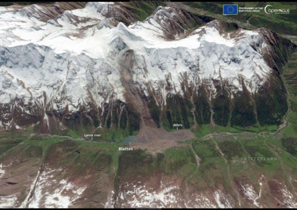
3D view of the Blatten mountain slide (European Union, Copernicus Sentinel-2 imagery)
The mass of debris destroyed much of Blatten. About 90 % of the village was buried under ice, mud, and rock. The landslide material covered a debris field several kilometres long and up to 200 meters deep. One of the consequences of the landslide was the blocking of the Lonza River flowing through the valley. Debris and ice formed a natural dam, causing water to form a lake near the remains of the village. This raised concerns about the risk of flooding downstream and led to ongoing monitoring of the water levels to protect communities downstream.
In the months after the disaster, engineers worked to assess the stability of the area and to manage the blocked river. The event has become a case study for scientists studying the effects of climate change on mountain landscapes. Mountain environments, especially in the high Alps, are shaped by glaciers and permafrost, permanently frozen ground acting like glue holding steep slopes together. As the climate warms, glaciers retreat and permafrost weakens, which can destabilize slopes and increase the risk of rockfalls and landslides.
Satellite observations played an important role in documenting and analysing the landslide. Instruments aboard satellites such as Sentinel-2 captured images of the disaster area before and after 28 May 2025. These data provide a valuable record of the landscape changes resulting from the landslide.
Exercises
- Satellite Map:
- Look at the satellite map. The true colour Sentinel-2 image of May 18, 2025 and the place names are shown.
- Try to identify important land cover classes (rocky areas, vegetated land, and ice/snow).
- Focus on the mountain slopes south of the village of Blatten. Is there anything special visible? What about the snow cover?
- Click on the layer selector in the upper right and switch the true colour image of May 30, 2025 on and off. What differences can you see? Zoom to the landslide area south of Blatten. What immediate changes caused by the landslide can you identify?
- Looking at the satellite maps, what can you say about the relief of the terrain? Where is it rugged, where smooth? Which indicators support your findings? Think about shadows and the sun position in different times of the year!
- Use the layer selector to switch the layer “Affected Areas” on and off and compare with your findings based on the satellite images.
- Use the layer selector to switch between the three true colour satellite images. In addition to the mountainslide, what other changes can you see? Think about seasonal changes in the snow cover and in the vegetation. Repeat the same with the False colour infrared images.
- Copernicus Browser:
- Open the case study area in the Copernicus Browser.
- Find the most recent cloudfree Sentinel-2 data covering the case study area.
- Use a false colour infrared representation.
- Compare the mountainslide area south of Blatten with the latest satellite image in the case study. Can you detect changes? Which reasons can you imagine? What about the vegetation cover? What about changes in the road network?
Links and Sources
| Downloads: | |
| PDF document of the case study (includes exercises): English, German, French, Italian, Spanish |
| Links: |
|