
Bauxite Mining in Australia
Located on the western side of Cape York Peninsula in northern Queensland, Australia, Weipa is a coastal town with a population of about 4,000 people. It is one of the most important mining towns in Australia due to rich deposits of bauxite, the main raw material used to produce aluminium.
The land around Weipa was traditionally owned and managed by Aboriginal peoples, particularly the Alngith people. Large bauxite deposits were discovered in the 1950s, and mining started in 1963. Weipa was built to support the mining industry, with housing, schools, a hospital, an airport, and a deep-water port. Several thousand jobs are directly or indirectly linked to bauxite extraction, transport, and port operations. Mining activity has shaped the infrastructure and daily life of the town. Although Weipa is remote and sparsely populated, it plays a key role in the global economy. Each year, tens of millions of tonnes of bauxite leave its port.
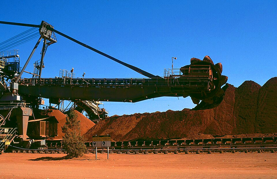
Huge bucket wheel excavator used in the bauxite mine.
Bauxite and Aluminium
Bauxite is the primary source of aluminium. To produce 1 tonne of aluminium, about 4–5 tonnes of bauxite are required. Aluminium is widely used because it is lightweight, durable, and recyclable. The bauxite reserves near Weipa are among the largest in the world, and the Weipa mining area produces roughly 35 million tonnes of bauxite per year, making it one of the biggest bauxite mining operations globally. Australia is the world’s largest exporter of bauxite, supplying major economies such as China, Japan, and South Korea.
Bauxite mining in Weipa is mainly open-pit mining, which requires clearing large areas of land. Individual mining sites can cover several square kilometres, affecting ecosystems, soil quality, and water systems. In Weipa, rehabilitation programs aim to restore vegetation within 5–10 years after mining is completed. Native plant species are replanted, and satellite monitoring is used to track recovery. Indigenous land use agreements play an important role, providing employment, training, and decision-making opportunities for local Aboriginal communities.
Satellite data is a valuable tool for managing mining activities and reducing environmental impacts. Earth-observing satellites, such as those in the Sentinel program, collect images of the same area every few days, allowing scientists and authorities to measure changes in land cover, vegetation health, and water quality over time.
Exercises
- Satellite Map:
- Look at the satellite image map. At start, the true color satellite images are active. Use the layer selector to deselect and select the true color layers from 2015 and 2025 by unticking/ticking the respective boxes.
- Which land cover classes can you identify? Think about water bodies, forests (mangroves along the rivers), bushland, and mining areas. Where can you see traces of human activities?
- Add the true color satellite image from 2015 and zoom in. Where can you identify mining activities?
- Add the satellite image from 2025 and repeat your assessment.
- While the main changes are related to the mining activities in the region, there are other, natural changes, too – compare e.g. the size of the town of Weipa in 2015 with that in 2025.
- Deselect the true color images and select the NDSI maps of 2015 and 2025, respectively. What can you say about the information content of these maps?
- Use the measure tool to assess the area affected by mining activities.
- Copernicus Browser:
- Open the case study araea in the Copernicus Browser.
- Find the most recent Sentinel-2 dataset covering the area displayed in the satellite map. Is it easy to find (more or less) cloud-free images? Why/why not?
- Select a true colour visualisation.
- Can you identify additional, recent changes in the area (check e.g. mining areas)?
- Select other types of visualisation. Try to identify applications, for which they are useful.
Links and Sources
| Downloads: | |
| PDF document of the case study (includes exercises): English, German, French, Italian, Spanish |
| Links: |
|