
East African Rift Valley
Tectonic Activities shape the Earth
The crustal movements and deformations driven by the movement of tectonic plates are powerful processes, shaping the surface of the Earth over millions of years. The Earth’s lithosphere, comprising the crust and upper mantle, sees immense forces related to the movement and interaction of these plates, leading to the formation of mountains, rift valleys, earthquakes, and other geological phenomena. Examples illustrating tectonic processes are the Himalayas, where tectonic plates collide, and the East African Rift Valley, where they are pulled apart.
A continent breaking apart – Rift Valleys
The East African Rift Valley is the result of divergent forces tearing apart the African continent. The Earth’s crust is being pulled apart along a system of rifts, resulting from tectonic plates moving away from each other. This so-called continental rifting forms the initial stages of plate boundary evolution. Magma from the mantle contributes to the thinning and eventual separation of continental landmasses. The rift valley’s landscape is characterized by steep cliffs, volcanic activity, and lakes.
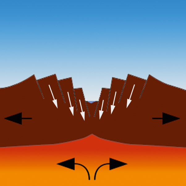
Schematic view of the formation of a rift valley.
Exercises
- Satellite Map:
- Look at the satellite map showing the overview satellite image of the larger region and switch the layer « Rifts » on and off. Which landscape features can you identify that are related to the rifts? Focus on mountain ridges, lakes, and valleys.
- Think about the mechanism of rift valleys, with tectonic plates moving away from each other. To which directions are the parts of the satellite map moving? Hint: the rifts form more or less in a right angle with respect to the plate movement.
- Now zoom to the area southeast of the Ethiopian capital Addis Ababa, which is presented in high resolution. Hint: deselect the layer « background », select the Sentinel-2 image from 2023, and zoom to the area highlighted by the red quadrangle « EastAfricanRiftValley_detail_extent ».
- Which elements of a rift valley can you identify here?
- Copernicus Browser:
- Open the case study area in the Copernicus Browser.
- Find the most recent Sentinel-2 data covering the case study area.
- Use a false colour infrared representation.
- Compare the extent of the evaporation ponds with that in the latest satellite image in the case study. Can you detect changes? Which reasons can you imagine? Think about seasons.
Links and Sources
| Downloads: | |
|
PDF document of the case study (includes exercises): English, German, French, Italian, Spanish |
|
|
|
This case study is covered on pages 24-25 of the printed ESA Schoolatlas – download the PDF document of the page: English, German, French, Italian, Spanish |
| Links: |
|