
From Lignite to Solar Power
The lignite mines near Böhlen, located near Leipzig, Germany, were part of the Central German lignite mining district, a major source of energy for the region throughout the 20th century. The mines began operations in the 1920s, extracting lignite (brown coal), which was used primarily for power generation and industrial purposes. At its peak, the open-cast mines covered a vast area and significantly altered the landscape, with deep pits and displaced earth creating an industrial wasteland.
By the 1990s, environmental concerns and a shift away from coal as a primary energy source led to the mine’s closure. In 1999, mining operations in the Zwenkau mine ceased, leaving behind a heavily scarred and barren landscape. However, in the years following the mine’s abandonment, extensive efforts were made to rehabilitate the area.
One of the most significant transformations involved flooding the former mine pits to create lakes such as the Hainer See and the Kahnsdorfer See, a process that began in the early 2000s. The lakes now cover a significant part of the surface. They have become a popular destination for recreation, offering activities such as sailing, fishing, and swimming.
A part of the surrounding land has also been converted to produce renewable energies. One example is the solar power plant “Energiepark Witznitz”, which covers about 5 km² of former lignite mine areas. With its energy production capacity of about 650 Megawatts it is one of Europe’s largest solar power plants and a symbol of the so-called Energiewende (Energy transition), the political decision to move from fossile to renewable energy sources.
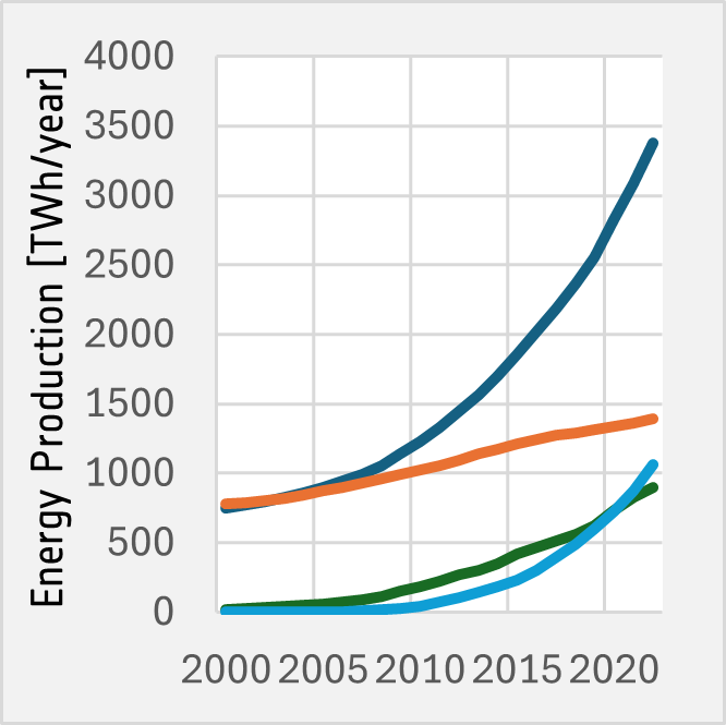
 Development of the global renewable energy production
Exercises
- Satellite Map:
- Look at the satellite map.
- What can you see? Describe the surface structures.
- Describe the different landcover and landuse zones visible in the satellite image. Identify natural and man-made structures.
- In which landcover zone is the solar power plant located? Try to find reasons for this selection of the location.
- Use the layer selector to toggle between the 2017 and the 2024 Sentinel-2 image. Focus on the lignite mine in the southwest of the satellite image. What changes can you identify between the two acquisition dates?
- Can you identify other landuse classes on areas where previously lignite mines were located?
- Copernicus Browser:
- Open the case study area in the Coeprnicus Browser.
- Find the most recent Sentinel-2 dataset covering the area displayed in the satellite map.
- Select a true colour visualisation.
- Can you identify additional, recent changes in the area (check e.g. water surfaces, solar power installations, and mining area)?
- Select the false colour infrared representation. Can you identify the land-use of the most intensely vegetated areas (represented by bright red colours)?
Links and Sources
| Downloads: | |
|
PDF document of the case study (includes exercises): English, German, French, Italian, Spanish |
|
|
|
This case study is covered on page 75 of the printed ESA Schoolatlas – download the PDF document of the page: English, German, French, Italian, Spanish |
| Links: |
|