
El Niño and La Niña
El Niño and La Niña are two opposite phases of the El Niño-Southern Oscillation (ENSO), a climate phenomenon that significantly affects global weather patterns. El Niño occurs when the surface waters of the central and eastern Pacific Ocean become unusually warm, while La Niña refers to cooler-than-normal ocean temperatures in that region. Both events disrupt weather systems worldwide, enhancing extreme weather conditions such as droughts, floods, and hurricanes.
The La Niña event of 2010–2011 was one of the strongest in recent history. It led to cooler-than-average sea surface temperatures in the central and eastern Pacific, which in turn influenced weather systems globally. This La Niña caused significant disruptions, such as floods in Australia, Thailand and the Philippines, and droughts in East Africa and in the southern U.S.
The 2015–2016 El Niño, one of the strongest on record, was characterized by unusually warm sea surface temperatures in the Pacific. This event disrupted weather patterns across the globe, with floods in South America and California and droughts in Southeast Asia and Australia, and made 2016 one of the warmest years on record.
Satellites like TOPEX/Poseidon and Jason together with geostationary weather satellites such as Meteosat provide data on sea surface temperature (SST), ocean surface height, and wind patterns. These measurements allow to detect early signs of El Niño or La Niña development by tracking anomalies in ocean temperatures and circulation patterns.
Exercises
- Satellite Map:
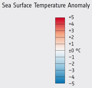
- Look at the Sea surface temperature anomaly maps from 2011 and 2015 and try to identify regions with lower/higher sea surface temperatures than normal.
- Try to estimate the width and the area of the affected ocean surface.
- In these maps, what are typical values for the anomalies (deviations from the normal temperature)?
- Can you imagine, in which way the temperature deviations affect the weather in and around these regions? Think about the role of the surface temperature for water evaporation and the subsequent formation of clouds and precipitation.
Links
| Downloads: | |
|
PDF document of the case study (includes exercises): English, German, French, Italian, Spanish |
|
|
|
This case study is covered on pages 34-35 of the printed ESA Schoolatlas – download the PDF document of the page: English, German, French, Italian, Spanish |
| Links: |
|