

Industrial Accident releasing Red Mud
On 4 October 2010, an industrial accident occurred near the town of Ajka in western Hungary. A dam around a reservoir at an alumina-processing plant collapsed and released a huge quantity of red mud, a waste product of the production of aluminium from bauxite. The material was highly alkaline, causing severe chemical burns and environmental damage.
The dam collapse released about 1.5 million cubic metres of red mud and water. The flood travelled through the Torna valley, reaching the settlements of Kolontár and Devecser with a depth up to 2.5 metres. It damaged hundreds of buildings and covered farmland and natural areas. Around 1,100 hectares were affected, including about 1000 ha of agricultural land and 90 ha of nature-conservation land.
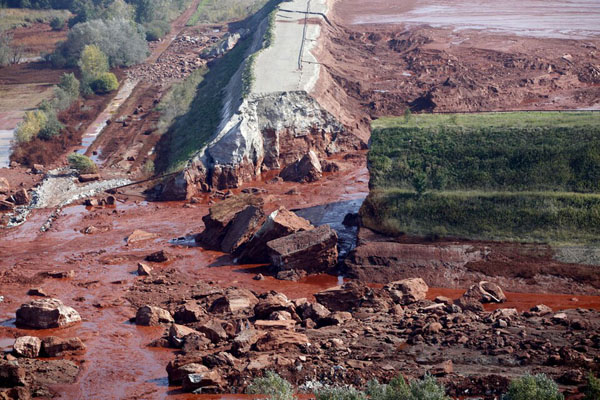
The failure of the reservoir dam in 2010 released large amounts of red mud (photograph: Kormányzati Kommunikációért Felelős Államtitkárság).
The consequences were serious. Ten people died and more than 120 were injured, suffering e.g. chemical burns. About 360 houses were affected, and 306 later had to be demolished. Three settlements were particularly damaged, but contamination affected a further 19 settlements. Roads, bridges, agricultural land and water ecosystems damaged, too.
The nearest rivers suffered the greatest ecological damage. The toxic material entered the Torna and Marcal Rivers, killing large numbers of aquatic organisms. The pollution travelled through the Rába river towards the Danube, making the disaster an international concern. The ICPDR’s (International Commission for the Protection of the Danube River) emergency warning system was activated, and downstream countries were informed. Fortunately, no major contamination was caused there.
The long-term consequences were both environmental and social. Large areas had to be excavated, cleaned and restored. About 760 hectares had been treated or decontaminated. Scientists continued monitoring soils, water and sediments because metals and other substances can remain in the environment even after the highly alkaline liquid has been neutralised.
Satellite data provided information about the disaster from above. On 9 October 2010, NASA’s Earth Observing-1 satellite acquired data of the spill. The images showed the red-orange pollution spreading away from the reservoir and across fields, allowing to assess the size, direction and changing extent of the spill over a large area. Later images such as those taken by Sentinel-2 show the recovery of the region.
Exercises
- Satellite Map:
- Look at the satellite image, which at launch shows the true color Sentinel-2 image from April 2026.
- Which landscape elements can you identify? Think about agriculture, water bodies, forests, built-up areas.
- Use the layer selector at the upper right of the map to deselect the true color Sentinel-2 image from April 2026. Now the true color image taken by EO-1 in October 2010 is visible. Where can you find the most prominent changes?
- Focus on the area west of the town of Ajka. Try to identify the position of the dam failure and describe the changes caused by it.
- Use the measure tool (area) to assess the area of the reservoir emptied by the dam failure.
- How do you think can an accident like this affect the people living there as well as downstream?
- While satellite image data can be very valuable for identifying areas affected by disasters, they have limitations. Which limitations come to your mind? Think about toxic or radioactive materials, can they be detected using satellite images?
- Copernicus Browser:
- Open the Copernicus Browser.
- Find the most recent Sentinel-2 dataset covering the area displayed in the satellite map.
- Select a natural colour representation.
- Zoom to the region around the town of Ajka.
- Can you identify additional, recent changes in the area?
Links and Sources
| Downloads: | |
 |
PDF document of the case study (includes exercises): English, German, French, Italian, Spanish |
| Links: |
|